|
||||||||||||||||||||||||||
| |||||||||||||||||||||||||||
|
Sierra Madre Business Web Pages ($125/year, with dedicated domain name, add $50 - Sierra Madre businesses only) Premium Advertiser Web Pages ($250/year, with dedicated domain name, add $50 - non-Sierra Madre businesses allowed, includes premium link placement and logo)
**************
*************
Arnold's Frontier Hardware & Gifts Rambo, Century 21 Village Realty Gem Plumbing, Heating and Air Conditioning Gwen Gordon, Fine Art/Graphic Design Solutions Hands 2 Health Wellness Center, Dr. Teresa Smith, Chiropractor Harlequin Art Gallery and Restoration Moe's Automotive Service Center Redstone Commercial Real Estate Reni Rose, Prudential CA Realty Ruth Richardson, Fine/Portrait Artist
|
Station Fire The following is partial coverage. There were some press releases that got posted that I deleted as I added new ones, but you'll see there's plenty of coverage as you scroll down the page. Someday, I may go through my old e-mails and add the press releases that got deleted, but I just don't have time right now. (9/6/09) 12 Noon Update from LA County Office of Emergency Managment re: Station Fire (Shelters, Evacuations and Road Closures) (9/4/09) Fire Marshal Rich Snyder Update Fire Marshal Rich Snyder posted the following on Facebook at 6pm: "Just got back from Chantry...The header is 3 miles North East of Chantry behind Newcombs." I contacted him and asked if I could quote him here, and his response was: ""Sure, but I can't confirm how close to Newcombs. The map and PIO showed/said it was in the drainage north of the power lines on the ridge 3 miles back from Chantry...I can confirm that the active fire today was far from Chantry." (9/4/09, 5:30 p.m.) City Fire Preparations Update The Sierra Madre Fire Department and City Officials continue to closely monitor the Station Fire. There is still no imminent danger to Sierra Madre residents and no evacuation orders have been issued. The City of Sierra Madre will maintain its current state of optimal preparedness throughout the Labor Day weekend.The Station Fire continues to be a slow-moving, terrain-driven fire that is currently 42% contained and has burned 148,258 acres. Current estimates place the closest edge of the fire at more than 3.5 miles north of the City. Incident Command indicates that areas south and east of Mt. Wilson are still a high priority. This includes the foothill communities, including Sierra Madre and Chantry Flats. Incident Fire officials have been giving the enthusiastic approval of the City to maintain an informational bulletin board at Kersting Court. At this time, the City is unsure when it will arrive or the duration it will be located within our City. The fire is now moving into heavy fuels, timber trees, and thick brush within the San Gabriel Wilderness north of the Cogswell Reservoir. This area has no historical record of burning and heavy smoke columns are expected. Current weather patterns are slightly pushing the fire further north and away from the city. This weather has shown to reduce the smoke in the area; however the heavy brush will continue to produce Pyrocumulus clouds, as see over the mountains this afternoon. Work on multiple protective fire breaks has been completed as of early this evening. The fire breaks are designed to hold the fire well north of the wildlife/urban interface. Firefighting operations will continue to take place both day and night to hold the fire north of the containment lines that have been established from Mt. Wilson to Highway 39. Controlled fire operations may also be conducted along these lines which are at least three ridges (or about 3.5 miles north) away from Sierra Madre. The controlled fire operations increase the effectiveness of the fire breaks, but should produce more smoke and flame in areas north of the City. The City of Sierra Madre would like to request that all residents to take time to review their emergency preparations and plans for all emergency situations including wildfire, mudslides, and earthquakes. Residents are encouraged to be “Ready for 7”; with 7 days worth of food, clothing, medicine, pet food and supplies should they have to leave their homes. Please visit the City’s website, www.cityofsierramadre.com for more information.As the fire predicted to continue to burn for many days, wild animals will be leaving their habitats and entering the City. Public Safety Officials warn residents to be cautious and leave all wildlife animals alone. For the safety of these animals, please do not feed them. Residents may want to take caution and keep small children and pets indoors. In compliance with an order from the US Forest Service and the LA County Sheriff Department, the City is closing until further notice Bailey Canyon, Mt. Wilson Trail and access roads to Chantry Flats. These closures will continue throughout the Labor Day weekend and will be strictly enforced. Fire conditions are changing constantly and this message contains the most current information the City of Sierra Madre has at this time. City Hall will be closed in observance of Labor Day Monday, September 7, 2009; however, City officials will continue to monitor and update the City’s message boards throughout the weekend. At this time, the City Council meeting for Tuesday, September 8, 2009, will take place at its regularly scheduled time. For more information, please tune into SMTV3, channel 3 on Time Warner Cable, or www.sierramadrepio.blogspot.com. eBlasts will also be sent out to registered users – to register for email alerts please visit www.cityofsierramadre.com, click on AccessSierraMadre, and then click CommunicationLink to register your email address.(9/4/09) 9/4/09 5pm Update from LA County Office of Emergency Management re: Station Fire (Shelters, Evacuations and Road Closures) *(Revised information on Animal Shelters and Newly Scheduled Community Meeting)* For the latest update City Press Release, see left column below Redstone ad (9/4/09) 9/4/09 AM Update from LA County Office of Emergency Management re: Station Fire (Shelters, Evacuations and Road Closures) (Received and posted at about noon) For the latest update City Press Release, see left column below Redstone ad (9/4/09) Station Fire Incident Management Team Hosts Community Meeting re: Fire Update The Incident Management Team (IMT) for the Station Fire hosted a community meeting last night to discuss the current status of the Station Fire. A crowd estimated at approximately 400 people turned out, with more than half of them Sierra Madreans. There was a large contingent of Pasadenans, and a smattering of Arcadians, Altadenans, and Monrovians. The meeting was held at Lee Chapel at Pasadena Nazarene Church. Mayor Maryann MacGillivray and Council Members Don Watts and John Buchanan were in attendance, as was City Manager Elaine Aguilar, Public Works Director Bruce Inman, Planning Director Danny Castro, Community and Personnel Services Director Elisa Weaver, Finance Director Karen Schnaider, and Library Services Director Toni Buckner. Fire Chief Steve Heydorff, Fire Marshal Rich Snyder and Battalion Chief Mike Bamberger were in attendance. Those are the people I saw, there may have been others there but I just didn't see them in the crowd. Representatives from the offices of Congressman David Dreier, State Senator Bob Huff, and Assemblyman Anthony Adams were also in attendance. Incident Commander Mike Deitrich was joined by Jody Noiron and Mike McIntyre of the Forestry Service, and Commander "Jimmy" Lopez of the Los Angeles Sheriff's Department.
LASD told people that when conditions allow, they will have 12 hours notice that they may be evacuated, and 2 hours notice of mandatory evacuations, based on "trigger points." They emphasized however that warning times might be more or less, depending on conditions and movement of the fire.
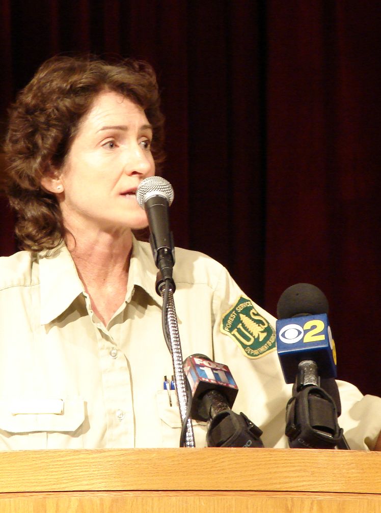
Forestry rep. Noiron had probably the most dramatic presentation, noting that
the fire has now officially been ruled an arson. "I hope we find the
person who started it, I don't know about you guys." She pointed out
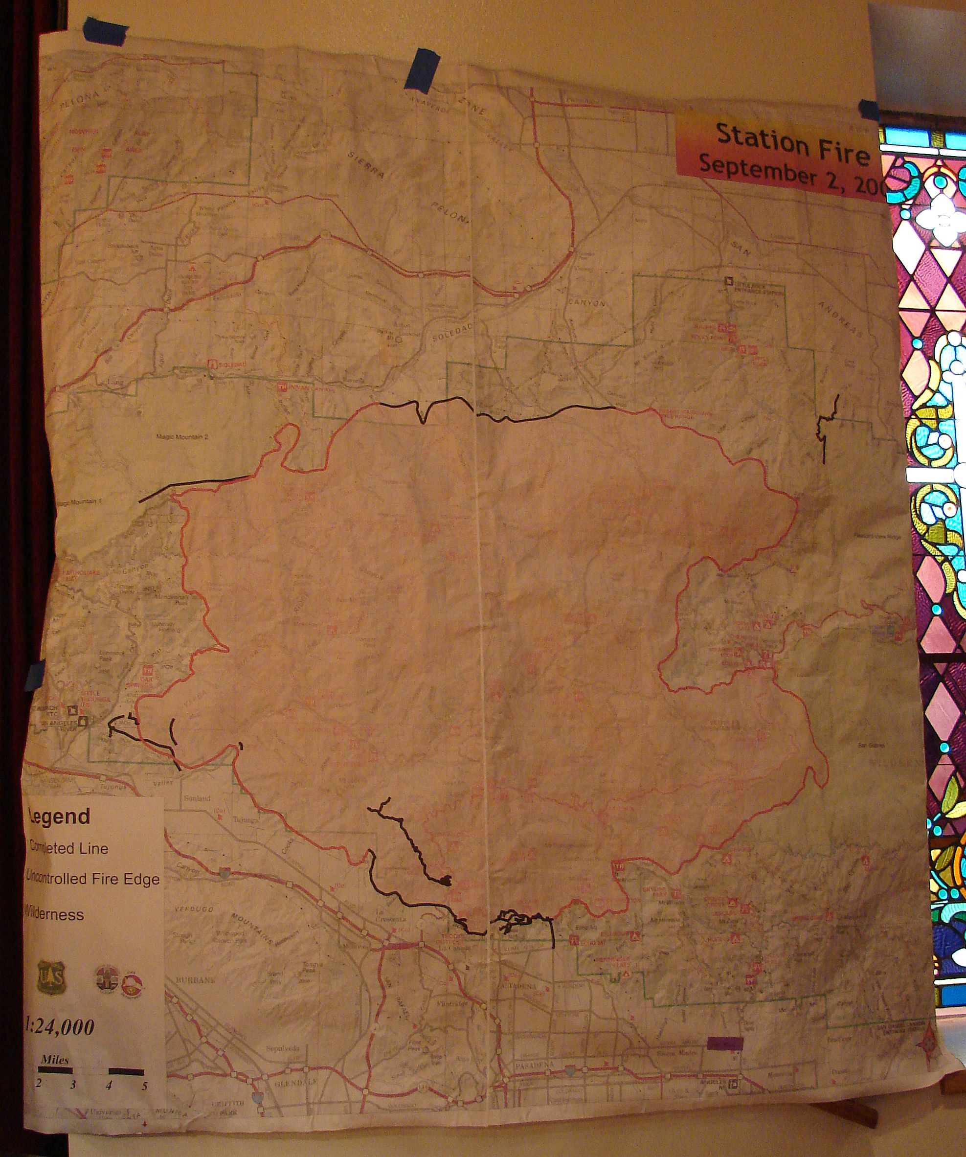
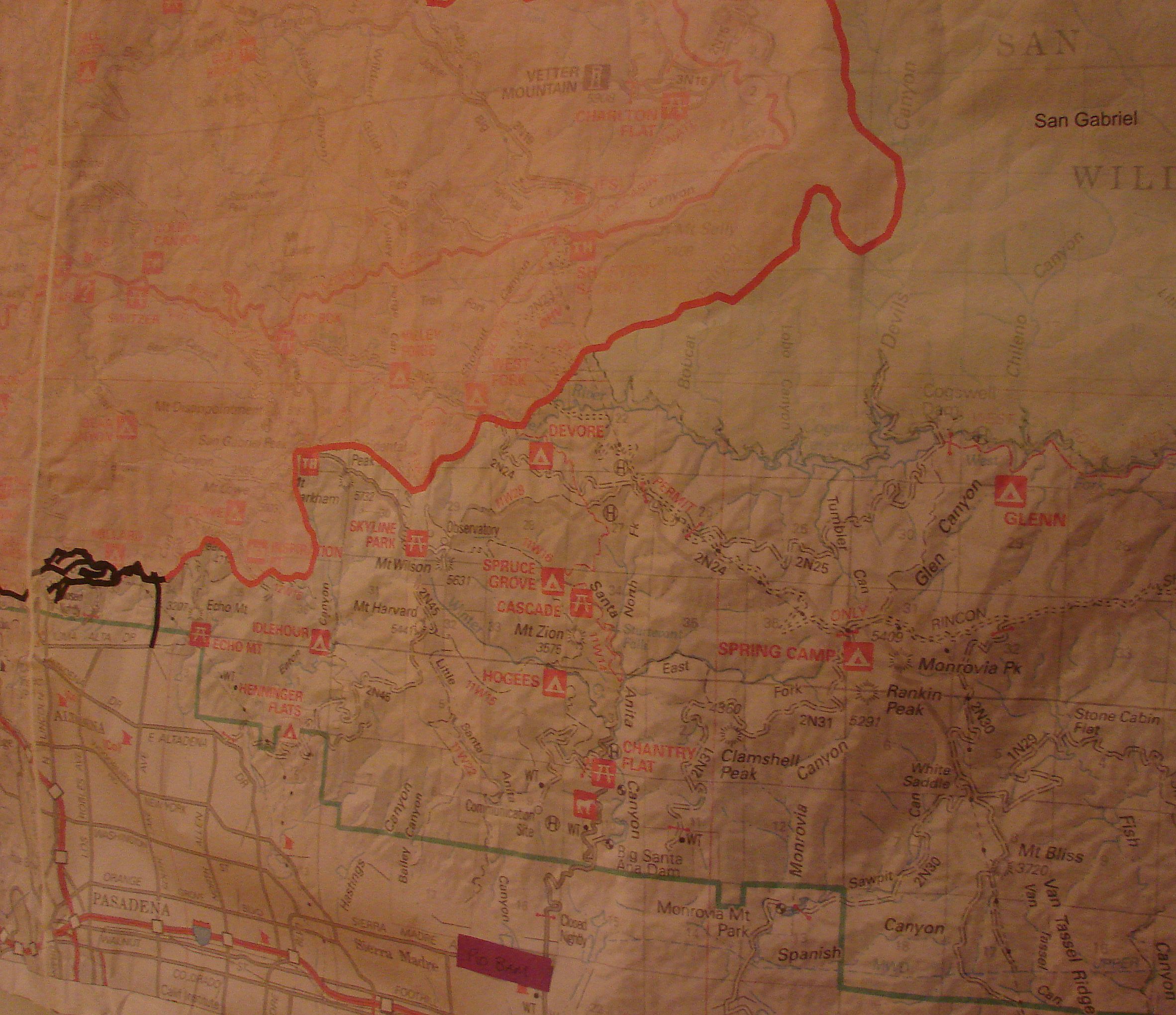
that the Forest records go Overall, officials seemed confident that, barring severe weather changes, they will be able to keep the fire out of Sierra Madre. Below are high resolution photos of the Incident map from the meeting, dated Sept. 2nd. The map on the left is the overall map, the map on the right is a close-up shot of our area.
I've uploaded an .mp3 audio file of the meeting that you can listen to by clicking here. It's over an hour long, so at 7mb, it's going to take a while to download. (My DSL took about a minute and a half.) (September 4, 2009, 10:30 a.m.) City is Prepared for Station Fire The Sierra Madre Fire Department and City Officials continue to closely monitor the Station Fire. As of this morning, there is still no imminent danger to Sierra Madre residents and no evacuation orders have been issued. The City of Sierra Madre will maintain its current state of optimal preparedness throughout the Labor Day weekend. The Station Fire continues to be a slow-moving, terrain-driven fire that is currently 42% contained and has burned 148,258 acres. Incident Command indicates that areas south and east of Mt. Wilson are still a high priority. This includes the foothill communities, including Sierra Madre and Chantry Flats. Please be aware that there is a potential for increased fire apparatus activity on land and by air. Fire officials sent hand crews to create a fire break between wilderness areas and the northern-most properties in Sierra Madre. This fire break is expected to extend from Altadena to Azusa and is designed to hold the fire north of the wildlife/urban interface. The City has been informed that controlled fire operations are included with contingency plans should the fire become a real threat to life and property in the foothill communities. The City of Sierra Madre would like to ask residents north of W. Carter Ave., north of E. Carter Ave, Mt. Wilson Trail Road, the Upper Canyon and Lower Canyon, and north of E. Grandview Ave from N. Mountain Trail eastward to renew their emergency preparations in the event that the City issues evacuation orders. Residents are reminded to be “Ready for 7” with 7 days worth of food, clothing, medicine, pet food and supplies should they have to leave their homes. The Community Recreation Center at 611 E. Sierra Madre Blvd. has been identified as an evacuation or check-in center should residents be forced to leave their homes. Pets in crates will be allowed in Sierra Vista Park. As the fire continues to burn closer to Sierra Madre, wild animals will be leaving the forest and entering the City. Public Safety Officials warn residents to be cautious and leave all wildlife animals alone. For the safety of these animals, please do not feed them. Residents may want to take caution and keep small children and pets indoors. In compliance with an order from the US Forest Service and the LA County Sheriff Department, the City is closing until further notice Bailey Canyon, Mt. Wilson Trail and access roads to Chantry Flats. These closures will continue throughout the Labor Day weekend and will be strictly enforced. Fire conditions are changing constantly and this message contains the most current information the City of Sierra Madre has at this time. City Hall will be closed in observance of Labor Day Monday, September 7, 2009; however, City officials will continue to monitor and update the City’s message boards throughout the weekend. At this time, the City Council meeting for Tuesday, September 8, 2009, will take place at its regularly scheduled time. For more information, please tune into SMTV3, channel 3 on Time Warner Cable, or www.sierramadrepio.blogspot.com. eBlasts will also be sent out to registered users – to register for email alerts please visit www.cityofsierramadre.com, click on AccessSierraMadre, and then click CommunicationLink to register your email address. (9/3/09) Station Fire Was Arson, Homicide Investigation Opened After a forensic examination of the point of origin of the Station fire, arson investigations from the Los Angeles County Sheriff's Department Arson/Explosives Detail, United States Forest Service, and Los Angeles County Fire Department have concluded the Station fire was the result of an act of arson. The Los Angeles County Sheriff's Department Homicide Bureau has initiated a homicide investigation into the tragic deaths of the two Los Angles County firefighters as a result of the fire. The investigation will be led by homicide investigators with the assistance of investigators from the Sheriff's Arson/Explosives Detail, United States Forest Service, and Los Angeles County Fire Department. There is no more information available at this time. As information becomes available that does not compromise the integrity of the investigation it will be released. Any questions should be directed to homicide Lieutenant Liam Gallagher at (323) 890-5500. (9/3/09) Angeles National Forest Announces Emergency Closure of the Southern Portion of the Angeles National Forest Because of the Actively Burning Station Fire ARCADIA, Calif.— As a result of extreme fire activity, and to protect public health and safety, Angeles National Forest officials are implementing an area closure of the southern portion of the Angeles National Forest, effective 12:00 p.m. today. The closure will be in place until it is determined that it is safe to reopen forest areas. Individuals or organizations holding special use permits for sanctioned activities within the Forest are exempt from this order. While the closure is in effect, going into or being upon National Forest System lands, roads, or trails within the closure area is not allowed. The closure will affect the use of all national forest recreational facilities, roads and hiking trails. A violation of the closure order is punishable by a fine of not more than $5,000 for an individual or $10,000 for an organization, or imprisonment for not more than six months, or both. The Station Fire Closure Area consists of all National Forest System lands within the Angeles National Forest south and east of California State Route 14 and California State Route 138. For further information about the closure or fires currently burning on the Angeles, contact the Fire Information Center at 626-821-6700. (9/3/09) 9/3/09 AM Update from LA County Office of Emergency Management re: Station Fire (Shelters, Evacuations and Road Closures) (Received and posted at about 10am) (9/2/09) Community Meeting will Update Residents on Fire Situation A community meeting will be conducted by the Station Fire Incident Management Team (IMT) on Thursday, September 3, at 7:00 p.m., to update residents of Pasadena, Sierra Madre and Arcadia about the Station Fire that has been burning since last Thursday. City of Sierra Madre officials will be present as well. The meeting will be at Pasadena Church of the Nazarene’s Lee Chapel, 3700 E. Sierra Madre Blvd. The IMT is conducting a series of meetings in San Gabriel Valley foothill communities over the next few days, on Friday, the meeting will be held at the Azusa Senior Center at 7:00 p.m. For more information call 626.355.7135. Comment on this article FYI - This meeting will quite possibly be a zoo. Here's the distribution list that the Office of Emergency Services sent their flier to: 20 De Mayo; A.C.C. News; Acorn; Action/Agua Dulce News; Actualidad; Aerotech News And Review; African Connection News; African Times USA, The; Al Borde; American Print Media; Antelope Valley Journal; Antelope Valley Press; Argonaut, The; Armenian Life Magazine; Armijo Newspapers And Public Relations; Asbarez Armenian Daily; Asian Entertainment Weekly; Asian Journal Publications, inc.; Associated Press; Avalon Bay News, The; Balita Media; Beachcomber; Beirut Times; Beverly Hills Courier; Beverly Hills Weekly; British Weekly; Burbank Leader; Business Life Magazine; California Community Newspaper; California Crusader News; California Examiner; California Journal For Filipino Americans; California Staats-Zeitung; Cam-News; Canyon News; China Daily press; Chinese American Times; City News Service; Claremont Courier; Claritaville; Coastal Community Newspaper; Contacto Magazine; Core Media Group, inc.; Country Journal; Cresenta Valley Sun; Daily Breeze; Daily Bruin; Daily News; Daily Trojan ; Downey Patriot; Downtown News; Duarte View, The; Eastern Group Publications, inc.; Easy Medalist; Easy Reader; El Aviso; El Clasificado; Episcopal Sun; Epoch Times, The (Los Angeles Branch); Fact Magazine; Foothill Leader, The; Fox Hills Digest; Friday Express; Gazette Newspapers; Glendale News-Press; Hollywood Weekly; Impacto USA; In Los Angeles; India Journal; Inglewood Today; Inland Valley Daily Bulletin; Inland Valley News; Investors's Business Daily; Jewish Community Chronicle; Jewish Journal Of Greater Los Angeles, The; Jewish Observer, The; Journal Newspapers, The; Joyce Media Inc.; Korea Central Daily, The; Korea Times, Los Angeles Edition; Kyodo News; La Canada Flintridge Outlook; La Canada Valley Sun; La Opinion; La Voz; La Voz Libre; La Watts Times; La Weekly; La Canada Flintridge Valley Sun; Lakewood Community News; Larchmont Chronicle; Latin Publications Inc.; Lighthouse; L'italo Americano; Long Beach & Corona Times Newspaper; Long Beach Business Journal; Los Angeles Bay News Observer Valley Edition (Inglewood/San Fernando Valley); Los Angeles Beat Newspapers; Los Angeles Business Journal; Los Angeles Garment & Citizen ; Los Angeles Jewish News ; Los Angeles Metropolitan Gazette; Los Angeles Sentinel; Los Angeles Star; Los Angeles Times; Los Angeles Times-Santa Monica Bureau; Los Angeles Wave and Los Angeles Independent Newspaper Group; Los Cerritos Community News; Los Feliz Ledger; Malibu Surfside News; Malibu Times; Massis Weekly; Metropolitan News Company; Midweek Balita/ Weekend Balita; Mondo Times; Monterey Park Cascades; New York Times; News-Press; North Valley Community News; North Valley Reporter; Northeast Sun (Highland Park, Cypress Park, Glassell Park, Eagle Rock, El Sereno, Lincoln Heights); Our Weekly; Pacific Citizen; Pakistan Today (Muslim World Today); Palisadian Post; Palos Verdes Peninsula News; Panorama; Pasadena Star-News; Pasadena Weekly; Press Telegram; Que Pasa Bulletin; Rafu Shimpo; Reporter, The; Ruby Gonzales; Saigon Times; San Dimas Community News; San Fernando Valley Business Journal; San Gabriel Valley Newspaper Group; San Gabriel Valley Tribune; San Marino Tribune; Santa Monica Daily Press; Santa Monica Observer; Shalom L.A.; Siam Media Weekly Thai Newspaper; Sierra Madre News.Net(website); Taliba; The Acorn Newspapers; The Lake Los Angeles News; The Magazine; The Montebello Community News; The Onion; The Palms-Village Sun; The Pasadena/San Gabriel Valley Journal (Pasadena, Altadena,and the San Gabriel Valley); The San Fernando Sun; The Signal; The Signal Tribune; The Star Newspapers; Tidings, The; Tolucan Times And Canyon Crier, The; Topanga Messenger; Valley News Group ; Valley Newspapers; Valley Observer; Valley Voice; Vanguard News; Venice Paper; Ventura County Star; Weather Scout; Westchester Gazzette; Westchester Playa Del Rey Hometown News; Westlake Revelations; Montebello Community News; Siam Media Weekley Thai Newspaper; Sierra Madre News.Net (Website); Sun Plublisher Inc.; Taliba; The Acorn Newspaper; The Epoch Times (Los Angeles Branch); The Lake Los Angeles News; The Magazine; The Onion; The Palm-Villiage Sun; The Pasadena/San Gabriel Valley Journal (Pasadena-altadena-San Gabriel Valley); The San Fernando Sun; The Signal; The Signal Tribune; The Star Newspaper; The Tidings; The Tolucan Times and Canyon Crier; Times Community News - Glendale; Topanga Messenger; Westchester Gazette; Westlake Revelations; American Homeowners Resource Center; Channel 11; Chola Reavley; City News HUB; Cop Seek; Efe News Services; Judy Hammond; Kerri Webb; Notimex; Peter Ye Sing Tao Daily (9/3/09) 9/2/09 at 7pm Update from LA County Office of Emergency Management re: Station Fire (Shelters, Evacuations and Road Closures) (Received and posted at about midnight)(9/2/09) 4pm Update from LA County Office of Emergency Management re: Station Fire (Shelters, Evacuations and Road Closures) (9/2/09) Station Fire Update, Sierra Madre Perspective Spoke with Chief Heydorf around 2:30, who told me that the fire is a couple ridges away, nothing imminent. I pointed out that in the last several days, I'd seen it look much closer than it does now, yet today the news keeps reporting that they are trying to make sure it doesn't get to Sierra Madre, Monrovia and Altadena. Chief told me that at the briefing this morning, they were told that if it gets here, it will be at least 4 days before it does, and there's a big IF. Here's what the Sierra Madre emergency blog has to say on the situation:Sierra Madre Fire Department and City Officials are closely monitoring the Station Fire. At this time, there is no imminent danger to Sierra Madre residents. The City of Sierra Madre has begun preparations in case the Station Fire enters Sierra Madre. At this time the Station Fire continues to be a slow moving fire and if the fire continues moving toward Sierra Madre, officials do not expect it to enter the City for at least five days. This prediction is contingent on if the current weather conditions continue. Today, fire officials began pre-treating the northern border of Sierra Madre by sending handcrews to work behind the northern-most properties in Sierra Madre creating a small fire break. This fire break is expected to extend from Altadena to Azusa. Residents north of Carter Avenue traveling east to Mira Monte Avenue and across Alegria Avenue to Grandview Avenue are ask to begin their emergency preparations in case the City has to evacuate residents. Residents are reminded to be “Ready for 7” with 7 days worth of food, clothing, medicine, pet food and supplies should they have to leave their homes. If the City evacuates residents, an evacuation center will be set up at the Community Recreation Center at 611 E. Sierra Madre Blvd. Crated pets will be allowed. As the fire continues to burn closer to Sierra Madre, wild animals will be leaving the forest and entering the City. Public Safety Officials warn residents to be cautious and leave them alone and to please not feed the wild animals. Residents may want to take caution and keep small children and pets indoors. In compliance with an order from the US Forest Service and the LA County Sheriff Department, the City is closing until further notice Bailey Canyon, Mt. Wilson Trail and the road up to Chantry Flats. For more information, please tune into SMTV3, channel 3 on Time Warner Cable, or www.sierramadrepio.blogspot.com. eBlasts will also be sent out to registered users – to register for email alerts please visit www.cityofsierramadre.com, click on AccessSierraMadre, and then click CommunicationLink to register your email address. Other sources of information about the Station Fire can be found at InciWeb the Incident Information System http://inciweb.org/ (9/2/09) COUNTY OF LOS ANGELES OFFICE OF EMERGENCY SERVICES UPDATE: Evacuation Areas Lifted for Residents
LOS ANGELES (Tue., Sept. 1, 2009 - 10:00 p.m.) – The Los Angeles County Fire Department has lifted the mandatory evacuations for residents only in the areas listed below:
· La Crescenta
(9/1/09) 12 Noon Update from LA County Office of Emergency Management re: Morris and Station Fires (Shelters, Evacuations and Road Closures) (9/1/09) Southern California Edison Updates Service Impact of Southern California Wildfires More than 2,700 Southern California Edison (SCE) customers were without power as of 10 a.m. PDT today in the wildfire areas, most of whom were in the San Bernardino County community of Yucaipa. There are 2,367 customers without service in the Yucaipa area where two fires are burning. In addition, there are 229 customers without service in Monrovia, an area affected by the Station Fire, and 108 customers without service in Azusa Canyon as a result of the Morris Fire. The total number of customers affected since the fires began is 4,669. Customer Impact
SCE Response
Wildfire Safety Tips
(8/31/09) City of Sierra Madre is Monitoring Station Fire The Sierra Madre Fire Department and City Officials are closely monitoring the Station Fire. At this time, there is no imminent danger to our residents. In compliance with an order from the US Forest Service and the LA County Sheriff Department, the City is closing until further notice Bailey Canyon, Mt. Wilson Trail and the road up to Chantry Flats. These are precautionary closures in response to the Los Angeles National Forest “Area Closure Order” which includes the mountain areas above Sierra Madre. If the fire becomes a threat to Sierra Madre, information will be posted on the City web site, SMTV-3, e-Blast, and City of Sierra Madre Emergency Blog http://sierramadrepio.blogspot.com/ or you may call (626) 355-7137. Other sources of information about the Station Fire can be found at InciWeb the Incident Information System http://inciweb.org/ and the web sites for the cities of Glendale http://www.ci.glendale.ca.us/, La Canada www.lacanadaflintridge.com/ and Pasadena www.cityofpasadena.net/.(8/31/09) 12:37pm Antonovich Launches Interactive Station Fire Map LOS ANGELES COUNTY – To ensure that residents affected by the Station Fire have access to updated information on evacuation and pet evacuation centers, Supervisor Antonovich has launched an interactive Google map of the Station Fire, which can be accessed by visiting http://antonovich.lacounty.gov/fire. The map will give residents:
Fire information is also available 24 hours a day by calling 211 or (626) 821-6700. (8/31/09) UPDATED - The Mt. Wilson Observatory Site is Being Updated Regularly The latest at 6:41pm: Monday, 31 Aug 09, 5:30 pm PDT - As I mentioned earlier, we have lost the new backup power to the mountain. In anticipation of a possible loss of all power to the Observatory, where the MWO webserver is located, this update site will be relocated to http://joy.chara.gsu.edu/CHARA/fire.php. I will continue posting material on the current server, but if and when it goes dark, please make a note now to try the other URL if you are interested in keeping in touch with this situation from our perspective. In this event, the Towercam will also go dark. In the meantime, please keep coming to this site. Here's a link to the site for updates Here's a link to the UCLA Tower Cam (8/31/09, 6:05am) COUNTY OF LOS ANGELES Office of Emergency Management PRESS RELEASE EVACUATION: La Crescenta Valley: (New Information) Mandatory evacuations are being enforced in the La Crescenta area due to possible fire activity. Residents living on the following streets need to vacate their residences by 6:00 am on Monday August 31st.
Rockdell St, Olive Ave., Shields St, Pine Glen Rd., Pinerigde Dr., Brierhaven Dr., Monutain Pine Dr., Timberlake Dr., Seapine Ln., Willowhaven Dr., Pinelawn Dr., Ridgepine Dr., Starfall Dr., Pineridge Pl at La Crescenta Ave., Fierro Cir., Rock Pine Ln., Mountain Pine Dr., Markridge Rd., Pinecone Rd., Highridge Rd., Cloudcrest Rd., Hopeton Rd., Hawkridge Dr., Broxbourne Ter, Quail Canyon Rd.
To help clarify, the streets listed above are located off of Rosemont , La Crescenta and Ramsdell and are north of Rockedell, Pineridge, Mountain Pine and Markridge Road.
A Red Cross shelter has been set up at Crescenta Valley High School located at 2900 Community Ave., La Crescenta, California (8/31/09) COUNTY OF LOS ANGELES Office of Emergency Management Click here for 4-page PRESS RELEASE re: Station and Morris Fires, Aug. 30th, 8pm Update with Shelter, Evacuation and Road Closures Altadena Evacuations: --Canyon Dell Drive area, one mile northeast of JPL. The area includes residences on: Canyon Crest Road, Aralia Road, Rising Hill Road and smaller streets accessed by those streets. This area is west of Millard Canyon, east of Arroyo Seco and north of Hahamongna Watershed Park. |
|
Copyright © 1998 - 2011 by The Coburn Group, Sierra Madre. All logos, trademarks or product names mentioned or displayed herein are the property of their respective owners. All photographs and videos on this site Copyright 1998 - 2011, by Bill Coburn, Sierra Madre, CA unless otherwise noted. Any reference to the City of Sierra Madre or Sierra Madre applies to the community of Sierra Madre and not the city government. The City of Sierra Madre, California government is not affiliated with Sierra Madre News.Net at this time. Any city government information provided herein has been previously published for public dissemination and is shown here as a public service of Sierra Madre News.Net without explicit permission of the government of the City of Sierra Madre. |


(9/6/09) Received 5:35pm Planned Burning Operations Near the Cogswell Dam Area Residents of the Los Angeles area and San Gabriel Valley may see an appreciable amount of smoke, and possibly some fire, over the next 24-36 hrs. in the Mt. Wilson and Cogswell Dam areas.
As part of their aggressive attack on the fire, crews may be burning vegetation ahead of the fire to establish a firm control line around the fire’s perimeter. The specific area considered for these operations is an east-west line extending from the East of Mt. Wilson to the western end of the Cogswell Reservoir.
Public safety and protection of property are top priorities. The potential burning will only be considered during favorable weather to minimize fire spread. As such, crews will wait for optimal conditions during the next 24-36 hours. Nighttime burns are possible. Firefighters will be constantly assessing the burn operations. If conducted, this operation will occur at a safe distance from homes and structures. No evacuations are necessary or anticipated. Residents should not be overly concerned, as the smoke and fire are part of the planned control activities. The understanding and cooperation of the surrounding communities are appreciated.